
Wismar topographic map
Interactive map
Click on the map to display elevation.
About this map
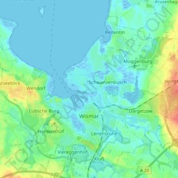
Name: Wismar topographic map, elevation, terrain.
Average elevation: 11 m
Minimum elevation: -4 m
Maximum elevation: 55 m
Other topographic maps
Click on a map to view its topography, its elevation and its terrain.
Hanstorf
Deutschland > Mecklenburg-Vorpommern > Nordwestmecklenburg > Stepenitztal
Hanstorf, Papenhusen, Stepenitztal, Grevesmühlen-Land, Nordwestmecklenburg, Mecklenburg-Vorpommern, 23936, Deutschland
Average elevation: 20 m
Schönberg
Deutschland > Mecklenburg-Vorpommern > Nordwestmecklenburg
Schönberg, Schönberger Land, Nordwestmecklenburg, Mecklenburg-Vorpommern, 23923, Deutschland
Average elevation: 26 m
Kalkhorst
Deutschland > Mecklenburg-Vorpommern > Nordwestmecklenburg > Kalkhorst
Kalkhorst, Klützer Winkel, Nordwestmecklenburg, Mecklenburg-Vorpommern, Deutschland
Average elevation: 27 m