
Make a donation
Shigatse topographic map
Click on the map to display elevation.
Make a donation
Shigatse
Shigatse Peace Airport began operations on 30 October 2010 after an Airbus A319 landed safely, making it Tibet's fifth commercial airport. It is located 43 kilometres from Samzhubzê District at Jangdam Township at an elevation of 3,782 metres. The airport will be capable of supporting 230,000 passengers annually by 2020.
Make a donation
About this map
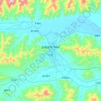
Name: Shigatse topographic map, elevation, terrain.
Average elevation: 4,049 m
Minimum elevation: 3,816 m
Maximum elevation: 5,363 m
Make a donation
Other topographic maps
Click on a map to view its topography, its elevation and its terrain.
Nagqu City
Nagqu is located in the northeast of Tibet. Nagqu Town is 330 kilometres (210 mi) by the China National Highway 109 northeast of Lhasa. Nagqu is bordered by Bayingolin and Hotan Prefectures of Xinjiang to the north, Haixi, Yushu Prefectures of Qinghai and Chamdo to the east, Nyingchi, Lhasa and Shigatse to the…
Average elevation: 4,864 m
Make a donation
Lhasa
Lhasa prefecture-level city roughly corresponds to the basin of the Lhasa River, a major tributary of the Yarlung Tsangpo. Exceptions are the north of Damxung County, which crosses the watershed of the Nyenchen Tanglha Mountains and includes part of the Namtso lake, and Nyêmo County, which covers the basin of…
Average elevation: 4,868 m
Make a donation
Chengguan District
Lhasa is the second most populous urban area on the Tibetan Plateau after Xining and, at an altitude of 3,656 metres (11,990 ft), Lhasa is one of the highest cities in the world. The city has been the religious and administrative capital of Tibet since the mid-17th century. It contains many culturally…
Average elevation: 4,325 m
Lhasa
Lhasa prefecture-level city roughly corresponds to the basin of the Lhasa River, a major tributary of the Yarlung Tsangpo. Exceptions are the north of Damxung County, which crosses the watershed of the Nyenchen Tanglha Mountains and includes part of the Namtso lake, and Nyêmo County, which covers the basin of…
Average elevation: 4,866 m
Make a donation
Lhasa
Lhasa prefecture-level city roughly corresponds to the basin of the Lhasa River, a major tributary of the Yarlung Tsangpo River. Exceptions are the north of Damxung County, which crosses the watershed of the Nyenchen Tanglha Mountains and includes part of the Namtso lake, and Nyêmo County, which covers the…
Average elevation: 4,866 m
Make a donation
Make a donation
Make a donation
Orba Co
China > Tibet > Rutog County > Dongru
Orba Co, also Wo Erba or Wo Erbacuo (Chinese: 窝尔巴错; pinyin: Wōěrbā cuò; Tibetan: འོར་པ་མཚོ, Wylie: 'or pa mtsho), is a lake in Rutog County in the Ngari Prefecture in the northwest of the Tibet Autonomous Region of China. It lies at an elevation of 5,209 metres (17,090 ft), to the southeast of Longmu Lake.
Average elevation: 5,246 m
Make a donation
Seni District
With an elevation of around 4,500 metres (14,800 ft), Nagqu has a harsh, alpine climate (Köppen EH), closely bordering on a subarctic climate (Dwc), with long, very cold and dry winters, and short, cool summers. In winter, temperatures frequently drop below −20 °C (−4 °F) at night and in summer…
Average elevation: 4,869 m
Make a donation
Riwoche County
Riwoche is the name of the county, the county capital, and the small village where the main monastery is located. Riwoche sits at around 3,400 m (11,200 ft) above sea level. The Dzi River flows through the region. The county grows barley and wheat. Khampa inhabitants of the area lives in houses made of wood.…
Average elevation: 4,389 m
Gonggar County
Gonggar County is located in southern Tibet and has a total area of 2,283 square kilometres (881 sq mi). The Yarlung Tsangpo River (Brahmaputra River), the mother river of Tibet, flows through the Gonggar County and among other counties of Shannan, and is thus rich in water resources. Set in west to east…
Average elevation: 4,378 m
Nam Tso
Namtso (Namco) is a lake that first formed during the Paleogene age, as a result of Himalayan tectonic plate movements. The lake lies at an elevation of 4,718 m (15,479 ft), and has a surface area of 1,900 km2 (730 sq mi). This salt lake is the largest lake in the Tibet Autonomous Region. However, it is not…
Average elevation: 4,920 m
Make a donation
Rutog County
Rutog County is located in northwestern Tibet, in the Ngari Prefecture, with a number of territorial borders. It is divided into 12 townships and 30 village committees. The average altitude of the county is 4,500 m (14,800 ft) with a maximum altitude of 6,800 m (22,300 ft).
Average elevation: 5,137 m
Make a donation
Make a donation
Chengguan District
Lhasa is the second most populous urban area on the Tibetan Plateau after Xining and, at an altitude of 3,656 metres (11,990 ft), Lhasa is one of the highest cities in the world. The city has been the religious and administrative capital of Tibet since the mid-17th century. It contains many culturally…
Average elevation: 4,325 m
Make a donation
Make a donation
Make a donation
Qüxü County
In the Tibetan language, the name means "water ditch." Qüxü County has a total area of 1,680 square kilometres (650 sq mi), with an average elevation of 3,650 metres (11,980 ft). The county is in the Yarlung Tsangpo valley, and is mostly relatively flat, but rises to the Nyainqêntanglha Mountains in the…
Average elevation: 4,514 m
Lhoka
Shannan has 1 district and 11 counties and its capital is Tsetang, which is located 183 kilometres from Lhasa. It covers an area of 79,700 square kilometres (30,800 sq mi), which includes part of South Tibet, a disputed territory currently under control of the Indian state of Arunachal Pradesh; the disputed…
Average elevation: 4,329 m
Make a donation
Rutog County
Rutog County is located in northwestern Tibet, in the Ngari Prefecture, with a number of territorial borders. It is divided into 12 townships and 30 village committees. The average altitude of the county is 4,500 m (14,800 ft) with a maximum altitude of 6,800 m (22,300 ft).
Average elevation: 5,137 m
Lhoka
Shannan has 1 district and 11 counties and its capital is Tsetang, which is located 183 kilometres from Lhasa. It covers an area of 79,700 square kilometres (30,800 sq mi), which includes part of South Tibet, a disputed territory currently under control of the Indian state of Arunachal Pradesh; the disputed…
Average elevation: 4,329 m
Make a donation
Lhünzhub County
Lhünzhub County is situated in central Tibet, approximately 65 km (40 mi) northeast of Lhasa. The county encompasses the Pengbo River Valley and the upper reaches of the Lhasa River, covering an area of 4,512 km2 (1,742 sq mi). The region is geologically diverse, with an average elevation of 4,000 metres…
Average elevation: 4,634 m
Make a donation
Chengguan
China > Tibet > Karuo District
Chengguan (Tibetan: ཁྲེང་ཀོན་གྲོང་རྡལ, Wylie: Khreng kon grong rdal, ZYPY: Chênggoin Chongdai; Chinese: 城关镇; pinyin: Chéngguān Zhèn) is a major town in the historical region of Kham in the eastern Tibet Autonomous Region of China. It is the seat of Karub District and…
Average elevation: 3,929 m
Ngamring County
The office place of the county is located in Kagar, population 1,700, at an elevation of 4,380 m (14,370 ft).
Average elevation: 5,083 m
Make a donation
Yanshiping Town
China > Tibet > Amdo County
Yanshiping (Chinese: 雁石坪镇; pinyin: Yànshípíng zhèn) is a small town physically situated in the southwest of Qinghai province, China. However, it is under the jurisdiction of Amdo County in the Nagqu Prefecture of the Tibet Autonomous Region. At an elevation of 4,720 metres (15,490 ft), it is one of…
Average elevation: 4,958 m
Rutog County
Rutog County is located in northwestern Tibet, in the Ngari Prefecture, with a number of territorial borders. It is divided into 12 townships and 30 village committees. The average altitude of the county is 4,500 m (14,800 ft) with a maximum altitude of 6,800 m (22,300 ft).
Average elevation: 5,137 m
Make a donation
Shelkar
China > Tibet > Tingri County
The town lies 7 kilometres (4.3 mi) off the Friendship Highway between Lhatse and Tingri, at an altitude of about 4,300 metres (14,100 ft), at the southern foot of 5,260 metres (17,260 ft) high Gyatso La. It is approximately 60 kilometres (37 mi) north-west of Mount Everest and just over 50 kilometres (31 mi)…
Average elevation: 4,831 m
Make a donation
Make a donation
Pangong Tso
China > Tibet > Rutog County
Pangong Tso or Pangong Lake (Tibetan: སྤང་གོང་མཚོ; Chinese: 班公错; pinyin: Bān gōng cuò; Hindi: पैंगोंग झील, romanized: Paiṅgoṅg jhīl) is an endorheic lake spanning eastern Ladakh and West Tibet situated at an elevation of 4,225 m (13,862 ft). It is 134 km…
Average elevation: 5,119 m
Make a donation
Lhoka
Shannan has 1 district and 11 counties and its capital is Tsetang, which is located 183 kilometres from Lhasa. It covers an area of 79,700 square kilometres (30,800 sq mi), which includes part of South Tibet, a disputed territory currently under control of the Indian state of Arunachal Pradesh; the disputed…
Average elevation: 4,329 m
Make a donation
Nang County
Nang is located in the south-west of Nyingtri, at the middle and lower reaches of the Yarlung Tsangpo River. The county seat of Nang County is situated in a region resembling an elephant's trunk, leading to the metaphorical designation of this area as "Nang" which translates to elephant. The average altitude…
Average elevation: 4,608 m
Make a donation
Make a donation