
Make a donation
Mimbres topographic map
Click on the map to display elevation.
Make a donation
About this map
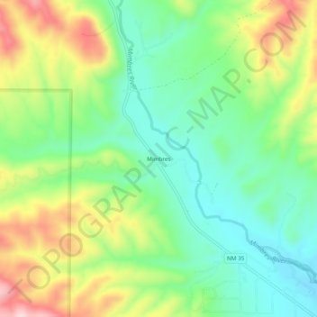
Name: Mimbres topographic map, elevation, terrain.
Location: Mimbres, Grant County, New Mexico, United States (32.83624 -107.99976 32.87624 -107.95976)
Average elevation: 1,881 m
Minimum elevation: 1,779 m
Maximum elevation: 2,053 m
Make a donation
Other topographic maps
Click on a map to view its topography, its elevation and its terrain.
Silver City
United States > New Mexico > Grant County
During the period from 1901 to 1964 when readings were taken at the city center (which is cooler and wetter than outlying and lower-elevation districts nearby), the coldest temperature recorded was −13 °F (−25 °C) on January 11, 1962, and the hottest 105 °F (40.6 °C) on July 5, 1901. The coldest month…
Average elevation: 1,850 m
Bayard
United States > New Mexico > Grant County
Bayard is located in the southern foothills of the Pinos Altos Range and Mogollon Mountains in the southwestern portion of New Mexico and situated east of the Continental Divide at an elevation of approximately 5,800 feet (1,800 m). Gila National Forest lies north from here. A semi-arid desert of predominantly…
Average elevation: 1,816 m
Silver City
United States > New Mexico > Grant County
During the period from 1901 to 1964, when readings were taken at the city center (which is cooler and wetter than outlying and lower-elevation districts nearby), the coldest temperature recorded was −13 °F (−25 °C) on January 11, 1962, and the hottest 105 °F (40.6 °C) on July 5, 1901. The coldest month…
Average elevation: 1,851 m
Make a donation