
Distrito Boquerón topographic map
Interactive map
Click on the map to display elevation.
About this map
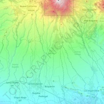
Name: Distrito Boquerón topographic map, elevation, terrain.
Location: Distrito Boquerón, Chiriquí, Panamá (8.44889 -82.62303 8.80893 -82.51897)
Average elevation: 706 m
Minimum elevation: 29 m
Maximum elevation: 3,422 m
Other topographic maps
Click on a map to view its topography, its elevation and its terrain.
Alto Boquete
Panamá > Chiriquí > Distrito Boquete
Alto Boquete, Distrito Boquete, Chiriquí, Panamá
Average elevation: 713 m
Chiriquí
Panamá > Chiriquí > Distrito David
Chiriquí, Distrito David, Chiriquí, Panamá
Average elevation: 22 m