
Thank you for supporting this site ❤️
Make a donation
Make a donation
Kelseyville topographic map
Click on the map to display elevation.
Thank you for supporting this site ❤️
Make a donation
Make a donation
Kelseyville
Kelseyville is a census-designated place (CDP) in Lake County, California, United States. Kelseyville is located 6 miles (9.7 km) southeast of Lakeport, at an elevation of 1,384 feet (422 m). The population was 3,353 at the 2010 census, up from 2,928 at the 2000 census.
Thank you for supporting this site ❤️
Make a donation
Make a donation
About this map
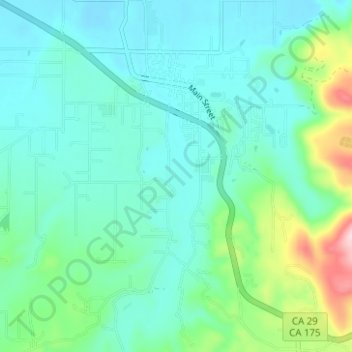
Name: Kelseyville topographic map, elevation, terrain.
Average elevation: 462 m
Minimum elevation: 409 m
Maximum elevation: 668 m
Thank you for supporting this site ❤️
Make a donation
Make a donation