
Annabichl topographic map
Interactive map
Click on the map to display elevation.
About this map
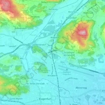
Name: Annabichl topographic map, elevation, terrain.
Location: Annabichl, Klagenfurt am Wörthersee, Kärnten, 9026, Österreich (46.63285 14.25561 46.67634 14.35656)
Average elevation: 484 m
Minimum elevation: 431 m
Maximum elevation: 734 m
Other topographic maps
Click on a map to view its topography, its elevation and its terrain.
St. Ruprecht
Österreich > Kärnten > Klagenfurt am Wörthersee
St. Ruprecht, Klagenfurt am Wörthersee, Kärnten, Österreich
Average elevation: 452 m
Seebach
Österreich > Kärnten > Klagenfurt am Wörthersee
Seebach, Klagenfurt am Wörthersee, Kärnten, 9071, Österreich
Average elevation: 593 m