
Thank you for supporting this site ❤️
Make a donation
Make a donation
Little Axe topographic map
Click on the map to display elevation.
Thank you for supporting this site ❤️
Make a donation
Make a donation
About this map
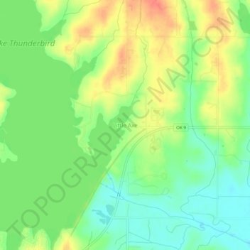
Name: Little Axe topographic map, elevation, terrain.
Average elevation: 321 m
Minimum elevation: 296 m
Maximum elevation: 352 m
Thank you for supporting this site ❤️
Make a donation
Make a donation
Other topographic maps
Click on a map to view its topography, its elevation and its terrain.
Sutton Urban Wilderness Park
United States > Oklahoma > Cleveland County > Norman
Average elevation: 365 m
Lake Thunderbird
United States > Oklahoma > Cleveland County > Norman > Little Axe
Average elevation: 334 m