
Roosendaal topographic map
Interactive map
Click on the map to display elevation.
About this map
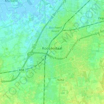
Name: Roosendaal topographic map, elevation, terrain.
Location: Roosendaal, Nordbrabant, Niederlande (51.49127 4.40694 51.56923 4.52319)
Average elevation: 6 m
Minimum elevation: -2 m
Maximum elevation: 14 m
Other topographic maps
Click on a map to view its topography, its elevation and its terrain.
Nispen
Niederlande > Nordbrabant > Roosendaal
Nispen, Roosendaal, Nordbrabant, Niederlande
Average elevation: 10 m
Heerle
Niederlande > Nordbrabant > Roosendaal
Heerle, Roosendaal, Nordbrabant, Niederlande
Average elevation: 6 m