
Anlier topographic map
Interactive map
Click on the map to display elevation.
About this map
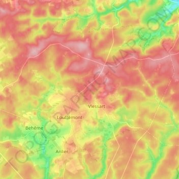
Name: Anlier topographic map, elevation, terrain.
Location: Anlier, Léglise, Neufchâteau, Luxembourg, Wallonie, Belgique (49.76752 5.57236 49.83732 5.70534)
Average elevation: 459 m
Minimum elevation: 371 m
Maximum elevation: 521 m
Other topographic maps
Click on a map to view its topography, its elevation and its terrain.
Assenois
Belgique > Luxembourg > Neufchâteau > Léglise
Assenois, Léglise, Neufchâteau, Luxembourg, Wallonie, Belgique
Average elevation: 420 m
Bombois
Belgique > Luxembourg > Neufchâteau > Léglise
Bombois, Ebly, Léglise, Neufchâteau, Luxembourg, Wallonie, 6642, Belgique
Average elevation: 472 m
Witry
Belgique > Luxembourg > Neufchâteau > Léglise
Witry, Léglise, Neufchâteau, Luxembourg, Wallonie, Belgique
Average elevation: 457 m