
Thank you for supporting this site ❤️
Make a donation
Make a donation
Wickham St. Paul topographic map
Click on the map to display elevation.
Thank you for supporting this site ❤️
Make a donation
Make a donation
About this map
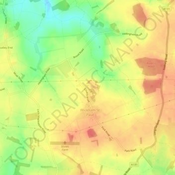
Name: Wickham St. Paul topographic map, elevation, terrain.
Location: Wickham St. Paul, Braintree, Essex, England, United Kingdom (51.98287 0.64532 52.01678 0.68655)
Average elevation: 74 m
Minimum elevation: 43 m
Maximum elevation: 94 m
Thank you for supporting this site ❤️
Make a donation
Make a donation
Other topographic maps
Click on a map to view its topography, its elevation and its terrain.