
Thank you for supporting this site ❤️
Make a donation
Make a donation
Blagdon topographic map
Click on the map to display elevation.
Thank you for supporting this site ❤️
Make a donation
Make a donation
About this map
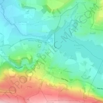
Name: Blagdon topographic map, elevation, terrain.
Location: Blagdon, North Somerset, England, United Kingdom (51.31615 -2.74018 51.35047 -2.68718)
Average elevation: 96 m
Minimum elevation: 21 m
Maximum elevation: 262 m
Thank you for supporting this site ❤️
Make a donation
Make a donation
Other topographic maps
Click on a map to view its topography, its elevation and its terrain.
Weston-super-Mare
United Kingdom > England > North Somerset > Weston-super-Mare
Average elevation: 13 m
Thank you for supporting this site ❤️
Make a donation
Make a donation
Thank you for supporting this site ❤️
Make a donation
Make a donation
Thank you for supporting this site ❤️
Make a donation
Make a donation
Thank you for supporting this site ❤️
Make a donation
Make a donation
Portishead Quays Marina
United Kingdom > England > North Somerset > Portishead > North Weston
Average elevation: 11 m
Thank you for supporting this site ❤️
Make a donation
Make a donation
Thank you for supporting this site ❤️
Make a donation
Make a donation
Thank you for supporting this site ❤️
Make a donation
Make a donation
Thank you for supporting this site ❤️
Make a donation
Make a donation
Thank you for supporting this site ❤️
Make a donation
Make a donation