
Thank you for supporting this site ❤️
Make a donation
Make a donation
Valdeancheta topographic map
Click on the map to display elevation.
Thank you for supporting this site ❤️
Make a donation
Make a donation
About this map
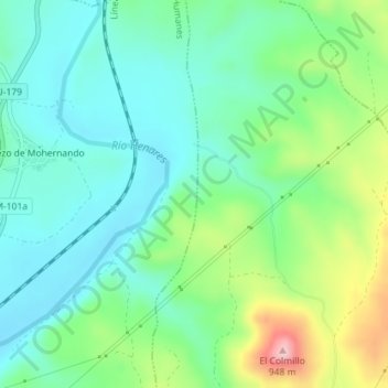
Name: Valdeancheta topographic map, elevation, terrain.
Location: Valdeancheta, Humanes, Guadalajara, Castilla-La Mancha, España (40.86119 -3.12013 40.88119 -3.10013)
Average elevation: 775 m
Minimum elevation: 711 m
Maximum elevation: 936 m
Thank you for supporting this site ❤️
Make a donation
Make a donation
Other topographic maps
Click on a map to view its topography, its elevation and its terrain.