
Thank you for supporting this site ❤️
Make a donation
Make a donation
Champi Alto topographic map
Click on the map to display elevation.
Thank you for supporting this site ❤️
Make a donation
Make a donation
About this map
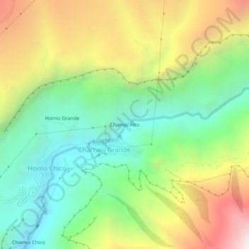
Name: Champi Alto topographic map, elevation, terrain.
Location: Champi Alto, Charcani Grande, Cayma, Arequipa, Perú (-16.27818 -71.46127 -16.23818 -71.42127)
Average elevation: 3,565 m
Minimum elevation: 2,897 m
Maximum elevation: 4,583 m
Thank you for supporting this site ❤️
Make a donation
Make a donation