
Brantford topographic map
Interactive map
Click on the map to display elevation.
About this map
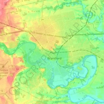
Name: Brantford topographic map, elevation, terrain.
Location: Brantford, Ontario, Canada (43.10186 -80.35373 43.19358 -80.19444)
Average elevation: 222 m
Minimum elevation: 188 m
Maximum elevation: 277 m
Other topographic maps
Click on a map to view its topography, its elevation and its terrain.
Little Current
Canada > Ontario > Manitoulin District > Northeastern Manitoulin and the Islands
Average elevation: 193 m
West Holland River (old)
Canada > Ontario > Simcoe County > Bradford West Gwillimbury
Average elevation: 222 m
Starkey Hill Conservation Area
Canada > Ontario > Wellington County > Puslinch > Arkell
Average elevation: 348 m
Lion's Head Provincial Nature Reserve
Canada > Ontario > Northern Bruce Peninsula
Average elevation: 206 m
Guelph
This region of Ontario has cold winters and warm, humid summers, falling into the Köppen climate classification Dfb zone, with moderately high rainfall and snowfall. It is generally a couple of degrees cooler than lower elevation regions on the Great Lakes shorelines, especially so in winter, the exception…
Average elevation: 344 m