
Thank you for supporting this site ❤️
Make a donation
Make a donation
Höfe topographic map
Click on the map to display elevation.
Thank you for supporting this site ❤️
Make a donation
Make a donation
About this map
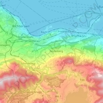
Name: Höfe topographic map, elevation, terrain.
Location: Höfe, Schwyz, Suisse (47.15027 8.68035 47.22257 8.81633)
Average elevation: 673 m
Minimum elevation: 402 m
Maximum elevation: 1,217 m
Thank you for supporting this site ❤️
Make a donation
Make a donation
Other topographic maps
Click on a map to view its topography, its elevation and its terrain.
Thank you for supporting this site ❤️
Make a donation
Make a donation
Stoos
La station est reliée à la vallée depuis le lieu-dit Schlattli, par le funiculaire Schwyz-Stoos qui est le plus raide au monde avec une pente atteignant les 110 % - ainsi qu'un petit téléphérique à faible débit - depuis Morschach. Le petit parking payant situé à proximité immédiate du funiculaire…
Average elevation: 1,232 m
Thank you for supporting this site ❤️
Make a donation
Make a donation