
Elleve topographic map
Interactive map
Click on the map to display elevation.
About this map
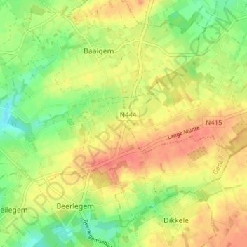
Name: Elleve topographic map, elevation, terrain.
Location: Elleve, Dikkelvenne, Gavere, Gent, Oost-Vlaanderen, 9630, België (50.89909 3.70841 50.93909 3.74841)
Average elevation: 42 m
Minimum elevation: 16 m
Maximum elevation: 63 m
Other topographic maps
Click on a map to view its topography, its elevation and its terrain.
Rotse
België > Oost-Vlaanderen > Gent > Dikkelvenne
Rotse, Dikkelvenne, Gavere, Gent, Oost-Vlaanderen, Vlaanderen, 9890, België
Average elevation: 22 m