
Thank you for supporting this site ❤️
Make a donation
Make a donation
Mount Brett topographic map
Click on the map to display elevation.
Thank you for supporting this site ❤️
Make a donation
Make a donation
About this map
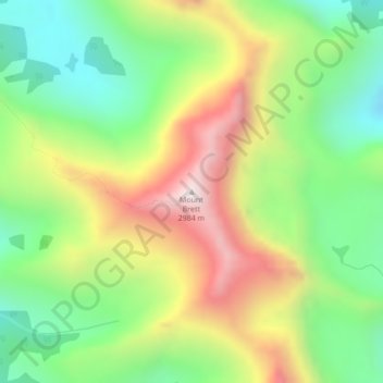
Name: Mount Brett topographic map, elevation, terrain.
Location: Mount Brett, Division No. 15, Alberta, Canada (51.16282 -115.82164 51.16292 -115.82154)
Average elevation: 2,491 m
Minimum elevation: 2,144 m
Maximum elevation: 2,975 m
Thank you for supporting this site ❤️
Make a donation
Make a donation
Other topographic maps
Click on a map to view its topography, its elevation and its terrain.
Columbia Icefield
Canada > Alberta > Division No. 15 > Area A (Kicking Horse/Kinbasket Lake)
Average elevation: 2,484 m