
Mourjou topographic map
Interactive map
Click on the map to display elevation.
About this map
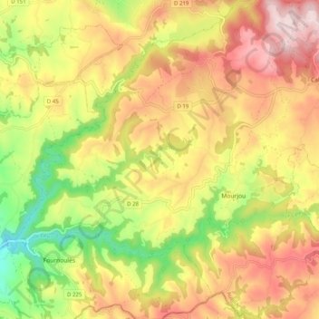
Name: Mourjou topographic map, elevation, terrain.
Average elevation: 495 m
Minimum elevation: 280 m
Maximum elevation: 689 m
Other topographic maps
Click on a map to view its topography, its elevation and its terrain.
Le Bos
France > Auvergne-Rhône-Alpes > Cantal > Puycapel
Le Bos, Calvinet, Puycapel, Aurillac, Cantal, Auvergne-Rhône-Alpes, France métropolitaine, 15340, France
Average elevation: 577 m
La Baresie
France > Auvergne-Rhône-Alpes > Cantal > Puycapel
La Baresie, Mourjou, Puycapel, Aurillac, Cantal, Auvergne-Rhône-Alpes, France métropolitaine, 15340, France
Average elevation: 538 m
Calvinet
France > Auvergne-Rhône-Alpes > Cantal > Puycapel
Calvinet, Puycapel, Aurillac, Cantal, Auvergne-Rhône-Alpes, France métropolitaine, 15340, France
Average elevation: 585 m
Le Faisan
France > Auvergne-Rhône-Alpes > Cantal > Puycapel
Le Faisan, Calvinet, Puycapel, Aurillac, Cantal, Auvergne-Rhône-Alpes, France métropolitaine, 15340, France
Average elevation: 592 m
Le Mas
France > Auvergne-Rhône-Alpes > Cantal > Puycapel
Le Mas, Mourjou, Puycapel, Aurillac, Cantal, Auvergne-Rhône-Alpes, France métropolitaine, 15340, France
Average elevation: 504 m
La Devèze
France > Auvergne-Rhône-Alpes > Cantal > Puycapel
La Devèze, Calvinet, Puycapel, Aurillac, Cantal, Auvergne-Rhône-Alpes, France métropolitaine, 15340, France
Average elevation: 557 m