Geolocate

Mont Noir topographic map

Interactive map

Click on the map to display elevation.

About this map

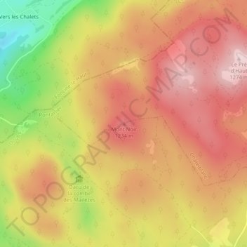
Name: Mont Noir topographic map, elevation, terrain.

Location: Mont Noir, Chapelle-des-Bois, Pontarlier, Doubs, Bourgogne-Franche-Comté, France métropolitaine, 25240, France (46.63458 6.09323 46.63468 6.09333)

Average elevation: 1,153 m

Minimum elevation: 952 m

Maximum elevation: 1,276 m

Other topographic maps

Click on a map to view its topography, its elevation and its terrain.

La Chaumoz

France > Bourgogne-Franche-Comté > Doubs > Chapelle-des-Bois > La Chaumoz

La Chaumoz, Chapelle-des-Bois, Pontarlier, Doubs, Bourgogne-Franche-Comté, France métropolitaine, 25240, France

Average elevation: 1,106 m

Chez l'Aimé

France > Bourgogne-Franche-Comté > Doubs > Chapelle-des-Bois

Chez l'Aimé, 12, Route des Marais, Chapelle-des-Bois, Pontarlier, Doubs, Bourgogne-Franche-Comté, France métropolitaine, 25240, France

Average elevation: 1,176 m

La Maison du Montagnon

France > Bourgogne-Franche-Comté > Doubs > Chapelle-des-Bois > Les Landrys

La Maison du Montagnon, 6, Chemin du Grand Tétras, Les Landrys, Chapelle-des-Bois, Pontarlier, Doubs, Bourgogne-Franche-Comté, France métropolitaine, 25240, France

Average elevation: 1,119 m

Les Landrys

France > Bourgogne-Franche-Comté > Doubs > Chapelle-des-Bois

Les Landrys, Chapelle-des-Bois, Pontarlier, Doubs, Bourgogne-Franche-Comté, France métropolitaine, 25240, France

Average elevation: 1,122 m

Chez Michel

France > Bourgogne-Franche-Comté > Doubs > Chapelle-des-Bois

Chez Michel, Chapelle-des-Bois, Pontarlier, Doubs, Bourgogne-Franche-Comté, France métropolitaine, 25240, France

Average elevation: 1,144 m

Les Antoine

France > Bourgogne-Franche-Comté > Doubs > Chapelle-des-Bois

Les Antoine, Chapelle-des-Bois, Pontarlier, Doubs, Bourgogne-Franche-Comté, France métropolitaine, 25240, France

Average elevation: 1,141 m