
Thank you for supporting this site ❤️
Make a donation
Make a donation
Kaltohmfeld topographic map
Click on the map to display elevation.
Thank you for supporting this site ❤️
Make a donation
Make a donation
Kaltohmfeld
Der Ort Kaltohmfeld befindet sich am Ostrand des Ohmgebirgsplateaus, etwa fünf Kilometer nordöstlich von Worbis. Kaltohmfeld ist mit knapp 500 m Höhe das höchstgelegene Dorf des Eichsfeldes.
Thank you for supporting this site ❤️
Make a donation
Make a donation
About this map
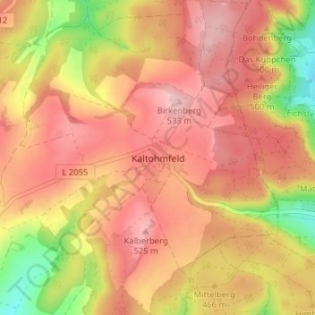
Name: Kaltohmfeld topographic map, elevation, terrain.
Average elevation: 468 m
Minimum elevation: 353 m
Maximum elevation: 534 m
Thank you for supporting this site ❤️
Make a donation
Make a donation