
Thank you for supporting this site ❤️
Make a donation
Make a donation
Negros topographic map
Click on the map to display elevation.
Thank you for supporting this site ❤️
Make a donation
Make a donation
Negros
Siquijor is an island located southeast of Negros Oriental. Area-wise, it is the third smallest in the country, with an area of 343.5 square kilometers (132.6 sq mi). Mount Malabahoc, also known as Mount Bandila‑an, is the highest point of the island, with its elevation reaching 628 meters (2,060 ft) above sea level. Marine terraces can be found in San Juan, as well as fossils of the giant clam tridacna in the island's plowed inland fields.
Thank you for supporting this site ❤️
Make a donation
Make a donation
About this map
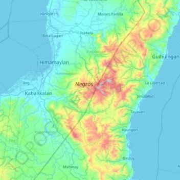
Name: Negros topographic map, elevation, terrain.
Average elevation: 210 m
Minimum elevation: -1 m
Maximum elevation: 1,440 m
Thank you for supporting this site ❤️
Make a donation
Make a donation