Geolocate

Guelph topographic map

Click on the map to display elevation.

Guelph

This region of Ontario has cold winters and warm, humid summers, falling into the Köppen climate classification Dfb zone (humid continental), with moderately high rainfall and snowfall. It is generally a couple of degrees cooler than lower elevation regions on the Great Lakes shorelines, especially so in winter, the exception being on some spring afternoons when the lack of an onshore breeze boosts temperatures well above those found lakeside.

Wikipedia (CC-BY-SA 3.0)

About this map

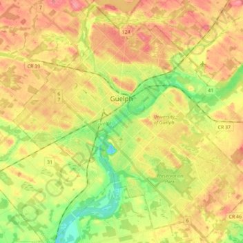
Name: Guelph topographic map, elevation, terrain.

Location: Guelph, Southwestern Ontario, Ontario, Canada (43.47381 -80.32691 43.59435 -80.15335)

Average elevation: 335 m

Minimum elevation: 292 m

Maximum elevation: 373 m

Other topographic maps

Click on a map to view its topography, its elevation and its terrain.

Toronto

Canada > Ontario > Toronto

Despite its deep ravines, Toronto is not remarkably hilly, but its elevation does increase steadily away from the lake. Elevation differences range from 76.5 metres (251 ft) above sea level at the Lake Ontario shore to 209 m (686 ft) ASL near the York University grounds in the city's north end at the…

Average elevation: 113 m

Peterborough

Canada > Ontario > Peterborough

Peterborough's topography is largely defined by land formations created by the receding Wisconsian glaciers 10,000–15,000 years ago. The South End and Downtown portions of the City sit on what was the bottom of the glacial Lake Peterborough—part of a glacial spillway created when glacial meltwaters from…

Average elevation: 235 m

Hamilton

Canada > Ontario > Hamilton

Average elevation: 181 m

London

Canada > Ontario > London > London

London has a humid continental climate (Köppen Dfb), though due to its downwind location relative to Lake Huron and elevation changes across the city, it is virtually on the Dfa/Dfb (hot summer) boundary favouring the former climate zone to the southwest of the confluence of the South and North Thames Rivers,…

Average elevation: 268 m

Guelph

Canada > Ontario > Guelph

This region of Ontario has cold winters and warm, humid summers, falling into the Köppen climate classification Dfb zone, with moderately high rainfall and snowfall. It is generally a couple of degrees cooler than lower elevation regions on the Great Lakes shorelines, especially so in winter, the exception…

Average elevation: 344 m

Minden

Canada > Ontario > Haliburton County > Minden Hills

Average elevation: 320 m

Kingston

Canada > Ontario > Kingston

Average elevation: 94 m

Papineau Creek

Canada > Ontario > Hastings Highlands

Average elevation: 473 m

Stoney Creek

Canada > Ontario > Hamilton > Stoney Creek

Average elevation: 135 m

Kawartha Lakes

Canada > Ontario > Kawartha Lakes

Average elevation: 269 m

Port Perry

Canada > Ontario > Durham Region > Scugog

Average elevation: 263 m

Kleinburg

Canada > Ontario > York Region > Vaughan

Average elevation: 206 m

Val Caron

Canada > Ontario > Sudbury District > Greater Sudbury

Average elevation: 295 m

Brantford

Canada > Ontario > Brantford

Average elevation: 238 m

St. Thomas

Canada > Ontario > St. Thomas

Average elevation: 231 m

Sauble Beach

Canada > Ontario > Bruce County

Average elevation: 188 m

Ottawa

Canada > Ontario > Ottawa > Ottawa

Average elevation: 99 m

Angus

Canada > Ontario > Simcoe County > Essa

Average elevation: 199 m

Cambridge

Canada > Ontario > Cambridge

Average elevation: 295 m

Windsor

Canada > Ontario > Windsor

Average elevation: 185 m

Barry's Bay

Canada > Ontario > Renfrew County > Madawaska Valley

Average elevation: 327 m

Wingham

Canada > Ontario > Huron County > North Huron

Average elevation: 318 m

Muskoka River

Canada > Ontario > Muskoka District > Bracebridge

Average elevation: 246 m

Ahmic Lake

Canada > Ontario > Magnetawan

Average elevation: 296 m

Woodstock

Canada > Ontario > Woodstock

Average elevation: 306 m

Keswick

Canada > Ontario > York Region

Keswick's geographical coordinates are 44.22°N, 79.45°W, and its elevation above sea level is 221m/762 ft. It has a geographical area of 16.25 km² according to Statistics Canada. It is bound on the north by Roches Point, the east by Woodbine Avenue, the south by East Gwillimbury (Ravenshoe Road) and the…

Average elevation: 228 m

Millbrook

Canada > Ontario > Peterborough County > Cavan-Monaghan

Peterborough's topography is largely defined by land formations created by the receding Wisconsian glaciers 10,000–15,000 years ago. The South End and Downtown portions of the city sit on what was the bottom of the glacial Lake Peterborough—part of a glacial spillway created when glacial meltwaters from…

Average elevation: 250 m

Catchacoma Narrows

Canada > Ontario > Trent Lakes

Average elevation: 302 m

Don River

Canada > Ontario > Old Toronto

Average elevation: 90 m

Sturgeon Falls

Canada > Ontario > Nipissing District

Average elevation: 209 m

Haliburton

Canada > Ontario

Average elevation: 358 m

Quinte West

Canada > Ontario > Quinte West

Average elevation: 110 m

Chelmsford

Canada > Ontario > Sudbury District > Greater Sudbury

Average elevation: 276 m

Moose Factory

Canada > Ontario > Cochrane District

Average elevation: 5 m

Kenora

Canada > Ontario

Average elevation: 182 m

Lake St. Peter

Canada > Ontario > Hastings Highlands

Average elevation: 423 m

Marmora

Canada > Ontario > Hastings County > Marmora and Lake

Average elevation: 200 m

Frontenac Provincial Park

Canada > Ontario > South Frontenac

Frontenac Provincial Park is located near the town of Sydenham, north of the city of Kingston, Ontario, Canada. The Government of Ontario has classified Frontenac Provincial Park as a natural environment park. The park lies on the Frontenac Axis, a topographic extension of the Canadian Shield, which connects…

Average elevation: 151 m

Quetico Provincial Park

Canada > Ontario

Average elevation: 432 m

Field

Canada > Ontario > Nipissing District

Average elevation: 248 m

Niagara Escarpment

Canada > Ontario

Average elevation: 299 m

Belleville

Canada > Ontario > Belleville

Average elevation: 107 m

Perth

Canada > Ontario

Average elevation: 313 m

Parry Sound

Canada > Ontario

Average elevation: 235 m

Rouge National Urban Park

Canada > Ontario > Toronto

Average elevation: 143 m

Night Hawk Lake

Canada > Ontario > Timmins

Average elevation: 275 m

Waterdown

Canada > Ontario > Hamilton > Waterdown

Average elevation: 203 m

Thedford

Canada > Ontario > Lambton County > Lambton Shores

Average elevation: 207 m

Cache Bay

Canada > Ontario > Nipissing District

Average elevation: 202 m

Ohsweken

Canada > Ontario

Average elevation: 208 m

James Bay

Canada > Ontario > Nipissing District

Average elevation: 217 m

Lake of Bays

Canada > Ontario > Muskoka District

Average elevation: 341 m

Pelee Island

Canada > Ontario

Average elevation: 173 m

Wallaceburg

Canada > Ontario > Chatham-Kent

Average elevation: 177 m

Earl Bales Park

Canada > Ontario > Toronto

Average elevation: 177 m

Rangers Bay

Canada > Ontario > Sudbury District > French River

Average elevation: 198 m

Dunchurch

Canada > Ontario > Parry Sound District > Whitestone

Average elevation: 262 m

Tottenham

Canada > Ontario > Simcoe County

Average elevation: 274 m

Prince Edward

Canada > Ontario

Average elevation: 118 m

Lambton

Canada > Ontario

Average elevation: 188 m

King City

Canada > Ontario > York Region > King

Average elevation: 302 m

Essex

Canada > Ontario

Average elevation: 193 m

Markdale

Canada > Ontario > Grey County > Grey Highlands

Average elevation: 421 m

Lac Seul

Canada > Ontario

Average elevation: 365 m

Burnt River

Canada > Ontario > Kawartha Lakes

Average elevation: 277 m

High Park

Canada > Ontario > Toronto

Average elevation: 97 m

Scarborough Bluffs

Canada > Ontario > Toronto

Average elevation: 120 m

Harlem Shoal

Canada > Ontario

Average elevation: 175 m

St. Johns

Canada > Ontario

Average elevation: 205 m

Niagara Escarpment

Canada > Ontario > Burlington

Average elevation: 216 m

Trenton

Canada > Ontario > Quinte West

Average elevation: 89 m

Sagamok

Canada > Ontario

Average elevation: 210 m

Pinehurst Lake

Canada > Ontario

Average elevation: 295 m

Docker Lake

Canada > Ontario

Average elevation: 377 m

Oneida Nation of the Thames

Canada > Ontario

Average elevation: 224 m

Bigwin Island

Canada > Ontario

Average elevation: 328 m

Upper Pergeon Lake

Canada > Ontario

Average elevation: 215 m

York River

Canada > Ontario

Average elevation: 397 m

Kawartha Lakes (city)

Canada > Ontario

Average elevation: 274 m

Fonthill

Canada > Ontario > Niagara Region

Average elevation: 193 m

Quinte West (city)

Canada > Ontario

Average elevation: 160 m

London

Canada > Ontario

London has a humid continental climate (Köppen Dfb), though due to its downwind location relative to Lake Huron and elevation changes across the city, it is virtually on the Dfa/Dfb (hot summer) boundary favouring the former climate zone to the southwest of the confluence of the South and North Thames Rivers,…

Average elevation: 269 m

Harley

Canada > Ontario > Brant County

Average elevation: 261 m

Lambton

Canada > Ontario

Average elevation: 191 m

Algoma District

Canada > Ontario

Average elevation: 360 m