
Thank you for supporting this site ❤️
Make a donation
Make a donation
Menziken topographic map
Click on the map to display elevation.
Thank you for supporting this site ❤️
Make a donation
Make a donation
About this map
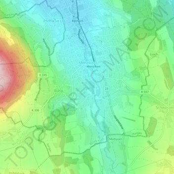
Name: Menziken topographic map, elevation, terrain.
Location: Menziken, Bezirk Kulm, Argovie, 5737, Suisse (47.22190 8.15593 47.24994 8.20788)
Average elevation: 625 m
Minimum elevation: 525 m
Maximum elevation: 857 m
Thank you for supporting this site ❤️
Make a donation
Make a donation
Other topographic maps
Click on a map to view its topography, its elevation and its terrain.
Lac de Hallwil
Suisse > Argovie > Bezirk Kulm > Birrwil
Il a une superficie moyenne de 10,3 km2 dont 5/6 sur le district de Lenzbourg et le reste sur le district de Hochdorf. Il se trouve à une altitude de 449 mètres et sa profondeur maximale est de 48 mètres. Sa largeur est d'environ 1 500 mètres.
Average elevation: 559 m