
Radaur topographic map
Interactive map
Click on the map to display elevation.
About this map
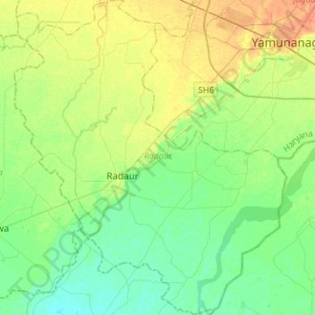
Name: Radaur topographic map, elevation, terrain.
Location: Radaur, Yamunanagar District, Haryana, 135133, India (29.93519 77.06538 30.15225 77.28268)
Average elevation: 268 m
Minimum elevation: 256 m
Maximum elevation: 287 m
Other topographic maps
Click on a map to view its topography, its elevation and its terrain.
Sector 37D
India > Haryana > Gurugram District
Sector 37D, Gurgaon, Gurugram District, Haryana, India
Average elevation: 217 m
Eiffel
India > Haryana > Gurugram District
Eiffel, Sohna, Gurugram District, Haryana, India
Average elevation: 253 m
Emerald Bay
Emerald Bay, Sector 104, Gurgaon, Gurugram, Haryana, India
Average elevation: 215 m
Central Park
Central Park, Sector 24, Gurgaon, Gurugram, Haryana, 122010, India
Average elevation: 248 m
Malra
India > Haryana > Mahendragarh > Malra
Malra, Mahendragarh, Haryana, India
Average elevation: 255 m
Ambala
India > Haryana > Ambala Cantt
Ambala, Ambala Cantt, Ambala, Haryana, 134002, India
Average elevation: 275 m
Gurgaon
India > Haryana > Gurugram District
Gurgaon, Gurugram District, Haryana, India
Average elevation: 237 m
Ferozepur Jhirka
India > Haryana > Ferozepur Jhirka > Ferozepur Jhirka
Ferozepur Jhirka, Nuh, Haryana, 122104, India
Average elevation: 256 m
Sector 107
Sector 107, Gurgaon, Gurugram, Haryana, India
Average elevation: 212 m
Sector 101
Sector 101, Gurgaon, Gurugram, Haryana, India
Average elevation: 215 m
Paposa
India > Haryana > Bawani Khera
Paposa, Bawani Khera, Bhiwani district, Haryana, 127035, India
Average elevation: 217 m