
Sierra Nevada topographic map
Interactive map
Click on the map to display elevation.
About this map
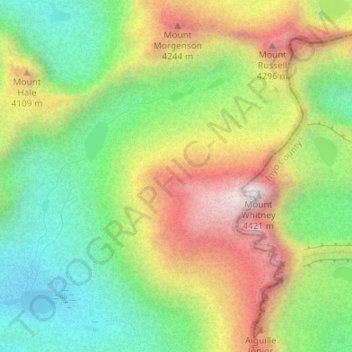
Name: Sierra Nevada topographic map, elevation, terrain.
Average elevation: 3,888 m
Minimum elevation: 3,492 m
Maximum elevation: 4,415 m
Other topographic maps
Click on a map to view its topography, its elevation and its terrain.
General Sherman Tree
Vereinigte Staaten von Amerika > Kalifornien > Tulare County
General Sherman Tree, Sherman Tree Trail, Tulare County, Kalifornien, 93262, Vereinigte Staaten von Amerika
Average elevation: 2,114 m