
Altass topographic map
Interactive map
Click on the map to display elevation.
About this map
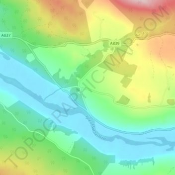
Name: Altass topographic map, elevation, terrain.
Location: Altass, Highland, Escócia, IV27 4EU, Reino Unido (57.94812 -4.56075 57.98812 -4.52075)
Average elevation: 82 m
Minimum elevation: -1 m
Maximum elevation: 258 m
Other topographic maps
Click on a map to view its topography, its elevation and its terrain.
Newtonmore
Reino Unido > Escócia > Highland > Newtonmore
Newtonmore, Highland, Escócia, PH20 1DF, Reino Unido
Average elevation: 285 m
Lago Ness
Reino Unido > Escócia > Highland > Dores
Lago Ness, Dores, Highland, Escócia, PH32 4BN, Reino Unido
Average elevation: 340 m