
Ahuacatlán topographic map
Interactive map
Click on the map to display elevation.
About this map
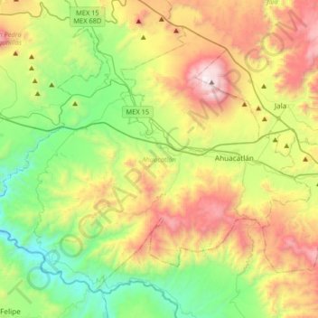
Name: Ahuacatlán topographic map, elevation, terrain.
Location: Ahuacatlán, Nayarit, Mexico (20.92416 -104.73166 21.17825 -104.40588)
Average elevation: 1,091 m
Minimum elevation: 375 m
Maximum elevation: 2,271 m
Other topographic maps
Click on a map to view its topography, its elevation and its terrain.
Punta Mita
Mexico > Nayarit > Bahía de Banderas > Corral del Risco
Punta Mita, Corral del Risco, Bahía de Banderas, Nayarit, Mexico
Average elevation: 8 m
San José del Valle
Mexico > Nayarit > Bahía de Banderas
San José del Valle, Bahía de Banderas, Nayarit, 63737, Mexico
Average elevation: 27 m
Tepetiltic
Mexico > Nayarit > San Pedro Lagunillas
Tepetiltic, San Pedro Lagunillas, Nayarit, Mexico
Average elevation: 1,520 m
Tepic
Mexico > Nayarit > Municipio de Tepic
Tepic, Municipio de Tepic, Nayarit, 63009, Mexico
Average elevation: 927 m