
Thank you for supporting this site ❤️
Make a donation
Make a donation
Maurice River topographic map
Click on the map to display elevation.
Thank you for supporting this site ❤️
Make a donation
Make a donation
About this map
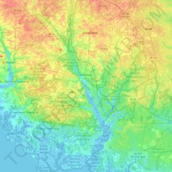
Name: Maurice River topographic map, elevation, terrain.
Location: Maurice River, Cumberland County, New Jersey, United States (39.20839 -75.08374 39.52614 -74.97832)
Average elevation: 16 m
Minimum elevation: -4 m
Maximum elevation: 44 m
Thank you for supporting this site ❤️
Make a donation
Make a donation
Other topographic maps
Click on a map to view its topography, its elevation and its terrain.
Commercial Township
United States > New Jersey > Cumberland County > Commercial Township
Average elevation: 5 m
Thank you for supporting this site ❤️
Make a donation
Make a donation
Port Elizabeth
United States > New Jersey > Cumberland County > Maurice River Township > Port Elizabeth
Average elevation: 4 m
Fairfield Township
United States > New Jersey > Cumberland County > Fairfield Township
Average elevation: 15 m