
Stoke Mandeville topographic map
Interactive map
Click on the map to display elevation.
About this map
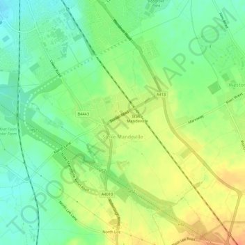
Name: Stoke Mandeville topographic map, elevation, terrain.
Location: Stoke Mandeville, Buckinghamshire, Inglaterra, Reino Unido (51.76974 -0.82084 51.80289 -0.76945)
Average elevation: 99 m
Minimum elevation: 80 m
Maximum elevation: 120 m
Other topographic maps
Click on a map to view its topography, its elevation and its terrain.
Dadford
Reino Unido > Inglaterra > Buckinghamshire
Dadford, Buckinghamshire, Inglaterra, MK18 5JX, Reino Unido
Average elevation: 131 m
Buckinghamshire
Reino Unido > Inglaterra > Buckinghamshire
Buckinghamshire, Grande Londres, Inglaterra, Reino Unido
Average elevation: 103 m