
Thank you for supporting this site ❤️
Make a donation
Make a donation
Antipolo topographic map
Click on the map to display elevation.
Thank you for supporting this site ❤️
Make a donation
Make a donation
About this map
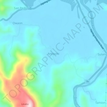
Name: Antipolo topographic map, elevation, terrain.
Average elevation: 66 m
Minimum elevation: 0 m
Maximum elevation: 458 m
Thank you for supporting this site ❤️
Make a donation
Make a donation
Other topographic maps
Click on a map to view its topography, its elevation and its terrain.
Zamboanga del Norte
Philippines > Zamboanga del Norte
It has an average elevation of 243.8 metres (800 ft), with Mount Dabiak in Katipunan as the highest peak at 2,600 metres (8,500 ft). Other parts, near the coastlines, are plains. The province's irregular coastline runs some 400 kilometres (250 mi) from north to south.
Average elevation: 77 m