
Thank you for supporting this site ❤️
Make a donation
Make a donation
Mexilhoeira Grande topographic map
Click on the map to display elevation.
Thank you for supporting this site ❤️
Make a donation
Make a donation
About this map
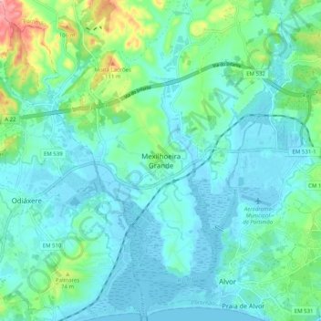
Name: Mexilhoeira Grande topographic map, elevation, terrain.
Location: Mexilhoeira Grande, Portimão, Faro, 8500-130, Portugal (37.11919 -8.65374 37.19919 -8.57374)
Average elevation: 28 m
Minimum elevation: -3 m
Maximum elevation: 145 m
Thank you for supporting this site ❤️
Make a donation
Make a donation
Other topographic maps
Click on a map to view its topography, its elevation and its terrain.