
Younger Lagoon topographic map
Interactive map
Click on the map to display elevation.
About this map
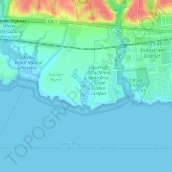
Name: Younger Lagoon topographic map, elevation, terrain.
Average elevation: 12 m
Minimum elevation: -4 m
Maximum elevation: 69 m
Other topographic maps
Click on a map to view its topography, its elevation and its terrain.
Santa Cruz Mission State Historic Park
USA > California > Santa Cruz
Santa Cruz Mission State Historic Park, Downtown, Santa Cruz, Santa Cruz County, California, USA
Average elevation: 23 m
Point Santa Cruz
USA > California > Santa Cruz
Point Santa Cruz, West Cliff Multipurpose Cycleway, Lighthouse/West Cliff, Downtown, Santa Cruz, Santa Cruz County, California, CA 95060-4619, USA
Average elevation: 3 m