
Make a donation
Raisin River topographic map
Click on the map to display elevation.
Make a donation
About this map
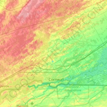
Name: Raisin River topographic map, elevation, terrain.
Average elevation: 73 m
Minimum elevation: 43 m
Maximum elevation: 124 m
Make a donation
Other topographic maps
Click on a map to view its topography, its elevation and its terrain.
Morewood
Canada > Ontario > Stormont, Dundas and Glengarry Counties > North Dundas
Average elevation: 77 m
Berwick
Canada > Ontario > Stormont, Dundas and Glengarry Counties > North Stormont
Average elevation: 75 m
Apple Hill
Canada > Ontario > Stormont, Dundas and Glengarry Counties > North Glengarry
Average elevation: 90 m
Iroquois
Canada > Ontario > Stormont, Dundas and Glengarry Counties > South Dundas
Average elevation: 83 m
Make a donation
Alexandria
Canada > Ontario > Stormont, Dundas and Glengarry Counties > North Glengarry
Average elevation: 84 m
South Stormont
Canada > Ontario > Stormont, Dundas and Glengarry Counties > South Stormont
Average elevation: 81 m
Lunenburg
Canada > Ontario > Stormont, Dundas and Glengarry Counties > South Stormont
Average elevation: 83 m
Morrisburg
Canada > Ontario > Stormont, Dundas and Glengarry Counties > South Dundas
Average elevation: 79 m
Make a donation