
Thank you for supporting this site ❤️
Make a donation
Make a donation
Tansen topographic map
Click on the map to display elevation.
Thank you for supporting this site ❤️
Make a donation
Make a donation
About this map
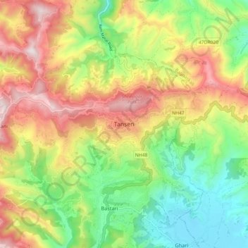
Name: Tansen topographic map, elevation, terrain.
Location: Tansen, Palpa, Lumbini Province, Nepal (27.82637 83.50691 27.90637 83.58691)
Average elevation: 1,059 m
Minimum elevation: 675 m
Maximum elevation: 1,547 m
Thank you for supporting this site ❤️
Make a donation
Make a donation