
Thank you for supporting this site ❤️
Make a donation
Make a donation
Hofheim am Taunus topographic map
Click on the map to display elevation.
Thank you for supporting this site ❤️
Make a donation
Make a donation
Hofheim am Taunus
Hofheim is also described in the Topographia Hassiae.
Thank you for supporting this site ❤️
Make a donation
Make a donation
About this map
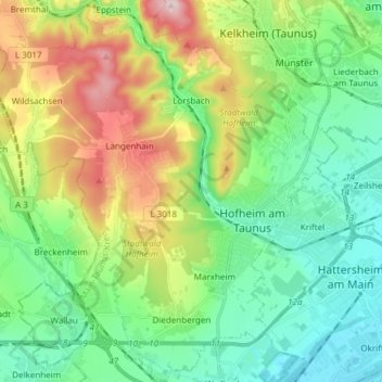
Name: Hofheim am Taunus topographic map, elevation, terrain.
Location: Hofheim am Taunus, Main-Taunus-Kreis, Hesse, 65719, Germany (50.04564 8.34332 50.14243 8.47436)
Average elevation: 198 m
Minimum elevation: 88 m
Maximum elevation: 440 m
Thank you for supporting this site ❤️
Make a donation
Make a donation