
Thank you for supporting this site ❤️
Make a donation
Make a donation
En l'Ormot topographic map
Click on the map to display elevation.
Thank you for supporting this site ❤️
Make a donation
Make a donation
About this map
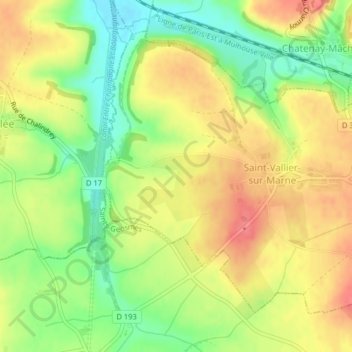
Name: En l'Ormot topographic map, elevation, terrain.
Average elevation: 375 m
Minimum elevation: 340 m
Maximum elevation: 404 m
Thank you for supporting this site ❤️
Make a donation
Make a donation
Other topographic maps
Click on a map to view its topography, its elevation and its terrain.
Saint-Vallier-sur-Marne
France > Grand Est > Haute-Marne > Saint-Vallier-sur-Marne
Average elevation: 381 m