
Make a donation
Briggs topographic map
Click on the map to display elevation.
Make a donation
Briggs
Briggs lies along U.S. Route 183 and FM 2657, northeast of Burnet. Its elevation is 1,102 feet (336 m), and it is located at 30°53′23″N 97°55′30″W / 30.88972°N 97.92500°W / 30.88972; -97.92500. Although Briggs is unincorporated, it has a post office, with the ZIP code of 78608. The population was 101 at the 2020 census.
Make a donation
About this map
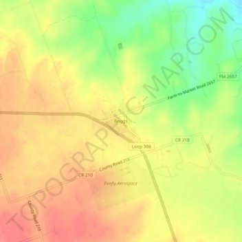
Name: Briggs topographic map, elevation, terrain.
Location: Briggs, Burnet County, Texas, 78608, United States (30.86877 -97.94581 30.90877 -97.90581)
Average elevation: 336 m
Minimum elevation: 295 m
Maximum elevation: 362 m
Make a donation
Other topographic maps
Click on a map to view its topography, its elevation and its terrain.
Make a donation
Inks Lake State Park
United States > Texas > Burnet County > Burnet
Conservation Pool Elevation usually stays around 888.22 ft. msl; however, this lake does fluctuate about 1 foot annually. Inks lake water clarity can be seen as clear to slightly stained mostly throughout the year. It tends to have higher turbidity during the rainy season due to excessive amounts of runoff.
Average elevation: 294 m
Make a donation