
Thank you for supporting this site ❤️
Make a donation
Make a donation
Mettur topographic map
Click on the map to display elevation.
Thank you for supporting this site ❤️
Make a donation
Make a donation
About this map
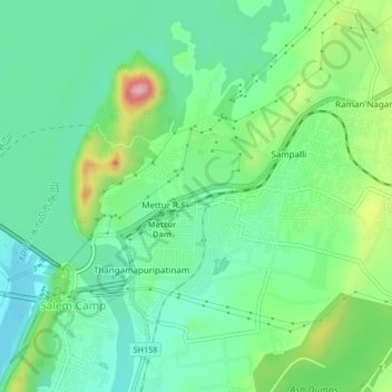
Name: Mettur topographic map, elevation, terrain.
Location: Mettur, Salem, Tamil Nadu, India (11.79009 77.81535 11.82348 77.85708)
Average elevation: 251 m
Minimum elevation: 188 m
Maximum elevation: 401 m
Thank you for supporting this site ❤️
Make a donation
Make a donation
Other topographic maps
Click on a map to view its topography, its elevation and its terrain.