
Chilli topographic map
Interactive map
Click on the map to display elevation.
About this map
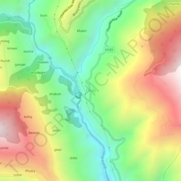
Name: Chilli topographic map, elevation, terrain.
Location: Chilli, Chaurah, Chamba, Himachal Pradesh, India (32.78781 76.12500 32.82781 76.16500)
Average elevation: 1,556 m
Minimum elevation: 1,021 m
Maximum elevation: 2,245 m
Other topographic maps
Click on a map to view its topography, its elevation and its terrain.
junu
India > Himachal Pradesh > Chaurah > Teesa
junu, Teesa, Chaurah, Chamba District, Himachal Pradesh, 176316, India
Average elevation: 1,909 m
ail
India > Himachal Pradesh > Chaurah
ail, Chaurah, Chamba District, Himachal Pradesh, India
Average elevation: 2,092 m
meas
India > Himachal Pradesh > Chaurah
meas, Chaurah, Chamba, Himachal Pradesh, India
Average elevation: 2,580 m
suila
India > Himachal Pradesh > Chaurah > suila
suila, Chaurah, Chamba, Himachal Pradesh, India
Average elevation: 2,373 m