
Thank you for supporting this site ❤️
Make a donation
Make a donation
Thurso topographic map
Click on the map to display elevation.
Thank you for supporting this site ❤️
Make a donation
Make a donation
About this map
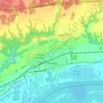
Name: Thurso topographic map, elevation, terrain.
Location: Thurso, Papineau, Outaouais, Quebec, Canada (45.58032 -75.25829 45.62634 -75.22886)
Average elevation: 68 m
Minimum elevation: 38 m
Maximum elevation: 128 m
Thank you for supporting this site ❤️
Make a donation
Make a donation
Other topographic maps
Click on a map to view its topography, its elevation and its terrain.
Thank you for supporting this site ❤️
Make a donation
Make a donation
Réserve écologique de la Forêt-la-Blanche
Canada > Quebec > Papineau > Mulgrave-et-Derry
Average elevation: 243 m