
Thank you for supporting this site ❤️
Make a donation
Make a donation
Berikai topographic map
Click on the map to display elevation.
Thank you for supporting this site ❤️
Make a donation
Make a donation
About this map
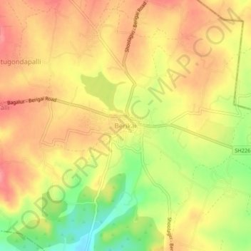
Name: Berikai topographic map, elevation, terrain.
Location: Berikai, Shoolagiri, Krishnagiri, Tamil Nadu, 635105, India (12.78522 77.95074 12.82522 77.99074)
Average elevation: 861 m
Minimum elevation: 808 m
Maximum elevation: 894 m
Thank you for supporting this site ❤️
Make a donation
Make a donation
Other topographic maps
Click on a map to view its topography, its elevation and its terrain.