
Forfar topographic map
Interactive map
Click on the map to display elevation.
About this map
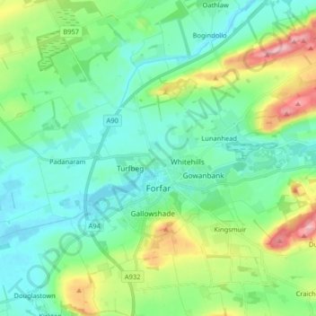
Name: Forfar topographic map, elevation, terrain.
Location: Forfar, Angus, Écosse, Royaume-Uni (56.60820 -2.96020 56.69719 -2.80990)
Average elevation: 95 m
Minimum elevation: 51 m
Maximum elevation: 227 m
Other topographic maps
Click on a map to view its topography, its elevation and its terrain.
Arbroath
Royaume-Uni > Écosse > Angus
Arbroath, Angus, Écosse, DD11 1DP, Royaume-Uni
Average elevation: 24 m
Kinnaber
Royaume-Uni > Écosse > Angus
Kinnaber, Angus, Écosse, DD10 9ER, Royaume-Uni
Average elevation: 19 m
Brechin
Royaume-Uni > Écosse > Angus > Brechin
Brechin, Angus, Écosse, DD9 6ET, Royaume-Uni
Average elevation: 71 m