
Thank you for supporting this site ❤️
Make a donation
Make a donation
Armada topographic map
Click on the map to display elevation.
Thank you for supporting this site ❤️
Make a donation
Make a donation
About this map
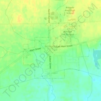
Name: Armada topographic map, elevation, terrain.
Location: Armada, Macomb County, Michigan, United States (42.83554 -82.89446 42.85044 -82.87028)
Average elevation: 228 m
Minimum elevation: 215 m
Maximum elevation: 239 m
Thank you for supporting this site ❤️
Make a donation
Make a donation
Other topographic maps
Click on a map to view its topography, its elevation and its terrain.
Anchor Bay Shores
United States > Michigan > Macomb County > Chesterfield Township
Average elevation: 176 m
Preston Corners
United States > Michigan > Macomb County > Shelby Charter Township
Average elevation: 198 m
Thank you for supporting this site ❤️
Make a donation
Make a donation
Shelby Charter Township
United States > Michigan > Macomb County > Shelby Charter Township
Average elevation: 205 m
Sterling Heights
United States > Michigan > Macomb County > Sterling Heights > Sterling Heights
Average elevation: 205 m