
Make a donation
Sulawesi topographic map
Click on the map to display elevation.
Make a donation
Sulawesi
The lowland forests on the island have mostly been removed. Because of the relative geological youth of the island and its dramatic and sharp topography, the lowland areas are naturally limited in their extent. The past decade has seen dramatic conversion of this rare and endangered habitat. The island also possesses one of the largest outcrops of serpentine soil in the world, which support an unusual and large community of specialized plant species. Overall, the flora and fauna of this unique center of global biodiversity is very poorly documented and understood and remains critically threatened.
Make a donation
About this map
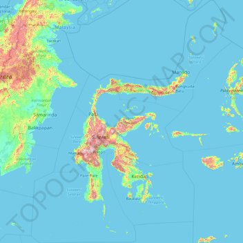
Name: Sulawesi topographic map, elevation, terrain.
Location: Sulawesi, Indonesia (-7.97221 116.34382 5.76395 127.75400)
Average elevation: 95 m
Minimum elevation: -2 m
Maximum elevation: 2,760 m
Make a donation
Other topographic maps
Click on a map to view its topography, its elevation and its terrain.
Make a donation
Make a donation
Make a donation
Make a donation
Alun-Alun Ambarawa
Indonesia > Central Java > Kabupaten Semarang > Tambakboyo > Katang
Average elevation: 499 m
Make a donation
Make a donation
Make a donation
Make a donation
Make a donation
Make a donation
Make a donation
Make a donation
Make a donation
Make a donation
Make a donation
Make a donation
Make a donation
Make a donation
Mount Galunggung
One plane—British Airways Flight 009, carrying 248 passengers and 15 crew traveling from Kuala Lumpur, Malaysia, to Perth, Australia, on June 24, 1982—accidentally entered the ash cloud at night, about 150 km (93 mi; 81 nmi) downwind of the volcano. All four engines failed due to the build-up of volcanic…
Average elevation: 1,286 m
Make a donation
Make a donation
Make a donation
Make a donation
Make a donation
Make a donation
Make a donation