
Make a donation
Sutrio topographic map
Click on the map to display elevation.
Make a donation
About this map
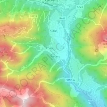
Name: Sutrio topographic map, elevation, terrain.
Location: Sutrio, Udine, Friuli-Venezia Giulia, 33020, Italy (46.47765 12.92601 46.52370 13.00355)
Average elevation: 897 m
Minimum elevation: 435 m
Maximum elevation: 1,737 m
Make a donation
Other topographic maps
Click on a map to view its topography, its elevation and its terrain.
Sella Nevea
Italy > Friuli-Venezia Giulia > Udine > Chiusaforte
Sella Nevea (Friulian: Nevee, German: Neveasattel, Slovene: Na Žlebeh), at an altitude of 1,195 m (3,921 ft), is a high mountain pass in the Julian Alps, in the Friuli Venezia Giulia region of northeast Italy. Sella Nevea also lends its name to a frazione of the Chiusaforte municipality and the nearby…
Average elevation: 1,545 m
Make a donation
Trinco / Trinko
Italy > Friuli-Venezia Giulia > Udine > Drenchia > Drenchia / Dreka > Trinco / Trinko
Average elevation: 742 m