
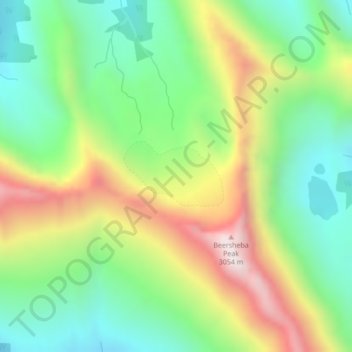
Brewster Glacier topographic map
Interactive map
Click on the map to display elevation.
About this map
Name: Brewster Glacier topographic map, elevation, terrain.
Average elevation: 2,521 m
Minimum elevation: 2,202 m
Maximum elevation: 3,028 m
Other topographic maps
Click on a map to view its topography, its elevation and its terrain.
Kananaskis Improvement District
Kananaskis Improvement District, Alberta, Kanada
Average elevation: 1,740 m
Peyto Glacier
Peyto Glacier, Trapper Peak Route, Columbia-Shuswap Regional District, Alberta, Kanada
Average elevation: 2,421 m
Crowfoot Glacier
Crowfoot Glacier, Crowfoot Mountain Approach Route, Alberta, Kanada
Average elevation: 2,550 m
Lac Ste. Anne
Lac Ste. Anne, Ste. Anne Trail, Lac Ste. Anne County, Alberta, T0E 0A0, Kanada
Average elevation: 740 m
North Saskatchewan River
North Saskatchewan River, County of Two Hills, Alberta, T5N 1J9, Kanada
Average elevation: 833 m
Lesser Slave River
Lesser Slave River, Township Road 730B, Municipal District of Lesser Slave River, Alberta, Kanada
Average elevation: 592 m