
Make a donation
Frontenac topographic map
Click on the map to display elevation.
Make a donation
About this map
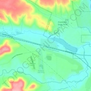
Name: Frontenac topographic map, elevation, terrain.
Average elevation: 243 m
Minimum elevation: 200 m
Maximum elevation: 338 m
Make a donation
Other topographic maps
Click on a map to view its topography, its elevation and its terrain.
Red Wing
United States > Minnesota > Goodhue County
According to the United States Census Bureau, the city has an area of 41.19 square miles (106.68 km2), of which 34.60 square miles (89.61 km2) is land and 6.59 square miles (17.07 km2) is water. The city is at the northern edge of the Driftless Area of karst topography.
Average elevation: 263 m
Make a donation