
汕头市 topographic map
Interactive map
Click on the map to display elevation.
About this map
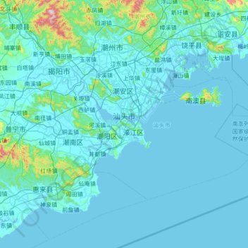
Name: 汕头市 topographic map, elevation, terrain.
Location: 汕头市, Guangdong, China (23.04054 116.23961 23.64342 117.15015)
Average elevation: 48 m
Minimum elevation: -2 m
Maximum elevation: 1,031 m
Other topographic maps
Click on a map to view its topography, its elevation and its terrain.
沙螺灣 Sha Lo Wan
China > Guangdong > 沙螺灣涌口 Sha Lo Wan Chung Hau
沙螺灣 Sha Lo Wan, 港珠澳大橋香港連接路 Hong Kong-Zhuhai-Macao Bridge Hong Kong Link Road, 沙螺灣 Sha Lo Wan, 沙螺灣涌口 Sha Lo Wan Chung Hau, 離島區 Islands District, Guangdong, Hong Kong, 000000, China
Average elevation: 43 m