
Thank you for supporting this site ❤️
Make a donation
Make a donation
Ash Shamal topographic map
Click on the map to display elevation.
Thank you for supporting this site ❤️
Make a donation
Make a donation
About this map
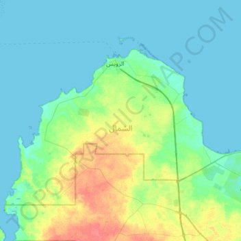
Name: Ash Shamal topographic map, elevation, terrain.
Location: Ash Shamal, Qatar (25.84524 50.95871 26.18298 51.49628)
Average elevation: 9 m
Minimum elevation: -1 m
Maximum elevation: 41 m
Thank you for supporting this site ❤️
Make a donation
Make a donation
Other topographic maps
Click on a map to view its topography, its elevation and its terrain.
Doha
Doha is located on the central-east portion of Qatar, bordered by the Persian Gulf on its coast. Its elevation is 10 m (33 ft). Doha is highly urbanized. Land reclamation off the coast has added 400 hectares of land and 30 km of coastline. Half of the 22 km² of surface area which Hamad International Airport…
Average elevation: 12 m