
Thank you for supporting this site ❤️
Make a donation
Make a donation
Alford topographic map
Click on the map to display elevation.
Thank you for supporting this site ❤️
Make a donation
Make a donation
About this map
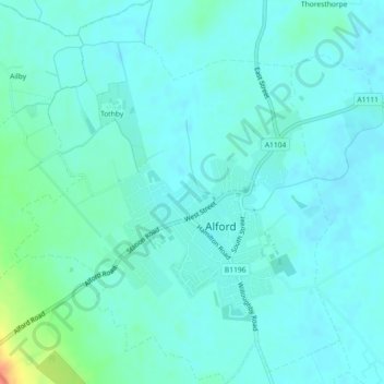
Name: Alford topographic map, elevation, terrain.
Location: Alford, East Lindsey, Lincolnshire, England, United Kingdom (53.24799 0.15338 53.27502 0.19181)
Average elevation: 10 m
Minimum elevation: 2 m
Maximum elevation: 47 m
Thank you for supporting this site ❤️
Make a donation
Make a donation
Other topographic maps
Click on a map to view its topography, its elevation and its terrain.